Day 10 : Sant'Anna di Vinadio to Rifugio Migliorero
| Previous: | Next: | |
| 9 : Rifugio Malinvern to Sant'Anna di Vinadio | 11 : Rifugio Migliorero to Ferrere |
| Distance: 16 km | Total time: 00:00:00 |
| Altitude gain: 1390 m loss: 1340 m | ( of which 00:00:00 resting time ) |
Here we deviated from the route in the guide book 'Through the Italian Alps', to avoid a piece on the road. If you follow the route described here, there are two passes to cross, so set out early. The reward is a stay in the beautiful Rifugio Migliorero, and an excellent meal.
Start by backtracking the last bit of yesterday's route, on the small asphalt road towards the statue and take the path up to Passo Tesina. From the pass, it's down to a very pleasant green upper valley and then down through the forest to the gravel road with a small hamlet. Turn left (no need to cross the river yet) and continue, first following the river, which you cross to reach the bigger road (without much traffic) to Rifugio Dahu de Sabernui in San Bernolfo, which has a very pleasant outside seating area for lunch or just a snack.
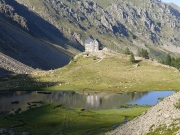
From there, briefly follow the road uphill through the settlement and take the path that immediate starts to climb towards the next pass: Passo di Laroussa. This part can be very hot in summer. After a steady climb, you reach the pass, for a quick rest and then a descent towards Rifugio Migliorero, which comes quickly into view, with its idyllic setting next to a lake in an otherwhise empty end of the valley.

